The remaining potential offshore Congo is unlocked by a quantitative interpretation of PGS' large MegaSurveyPlus dataset. The geology of the region is revealed beyond block boundaries, enabling new insights into the petroleum systems, play fairways, and analogous discoveries. Opportunities can now be analyzed in reliable prestack detail down to prospect level, to improve investment decisions.
Offshore Congo’s proven pre and postsalt petroleum systems have been generating oil and gas for over 50 years. The area has been extensively covered with 3D seismic data. However, the data was acquired piecemeal, with a focus on specific targets, and without the regional context required to fully comprehend leads in their wider setting.
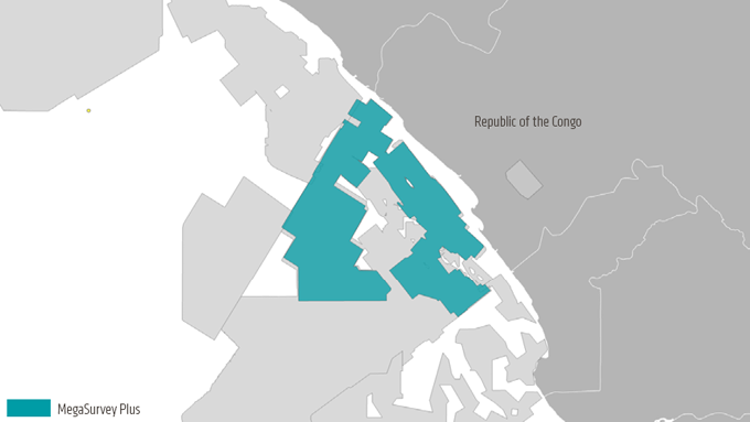
SNPC partnered with PGS to repair this fragmented view. The Congo MegaSurvey, matched and merged final full-stack data from many legacy volumes to create 22 415 sq. km of 3D data, 5 331 km of matched 2D seismic data. They then added regional interpretation with key horizons tied to released well data.
In 2019, that coverage was enhanced by MegaSurveyPlus reprocessing of 3D data across nearly 9 000 sq. km of open and held acreage.
Congo MegaSurveyPlus comprises 3D data reprocessed from field tapes using modern broadband workflows
Reimaging to Reduce Uncertainty
The Congo MegaSurveyPlus was constructed by reprocessing field data from the Congo MegaSurvey, using modern broadband imaging methodologies, including the elimination of multiples and depth velocity model building.
Using a MegaSurveyPlus workflow, input data with various acquisition parameters and a legacy processing baseline benefited from these advanced imaging efforts. The result is a consistent regional dataset and superior images that reveal more of the petroleum system than has been seen before.
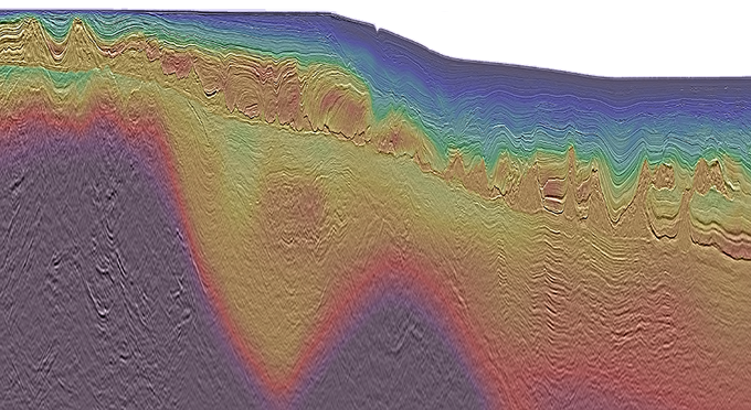
MegaSurveyPlus overlayed by interval velocity provides a clearer image across the margin
New interpretations are now possible. Based on regional depth imaging across the Congo offshore area, these are significantly more reliable than our previous understanding based on legacy time imaging.
- Clear 3D presalt images: large lateral variations in velocity introduced by the carbonates and complex salt bodies are handled correctly, on a regional basis, allowing a clear 3D image under the salt for the first time
- Petroleum system revealed: elements can be understood on a basin-wide scale
- Accurate salt geometry: allows an understanding of its role in sealing, hydrocarbon migration and trap development
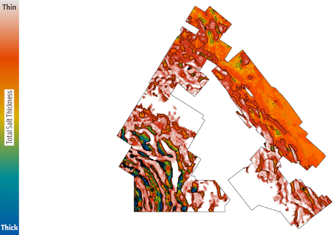
Regional coverage of salt thickness provides insight into seal potential, migration pathways, and trapping mechanisms revealing potential outside the block
Going Beyond Full Stack Insights
PGS set out to demonstrate the feasibility of using the clear structural image and consistently reprocessed prestack data provided by the Congo MegaSurveyPlus to generate reliable attributes for lead identification across a portion of the shelf.
The team took an integrated approach, treating the angle stacks with reservoir-orientated prestack conditioning (ResOP) to enhance the prestack seismic data. This data was used as input to our Prospect Scanner workflow, to estimate relative P-impedance, S-impedance, and Vp/Vs, allowing regional lithology and fluid screening.
Finally, applying the available well data to understand the rock-physics relationships in the area, a correlation was made from petrophysical properties to seismic response found hydrocarbon reservoirs, which typically display a low relative acoustic impedance and Vp/Vs compared to brine filled reservoirs.
The image below provides an example of prestack attributes over a drilled hydrocarbon accumulation. The well data was integrated into the interpretation of the seismic data. An anomaly conforming to the structure provides confidence that the prestack data generated across the MegaSurveyPlus can be used for interpretation.
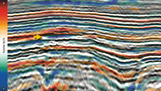
Drilled hydrocarbon accumulations exhibit low relative acoustic impedance (blue) and low relative Vp/Vs values (blue)
Below is another anomaly, which corresponds to a low acoustic impedance and low Vp/Vs response, situated within a structural trap induced by halokinesis. With the concept validated through examples such as these, screening for remaining opportunities near existing infrastructure in open blocks can be undertaken with confidence.
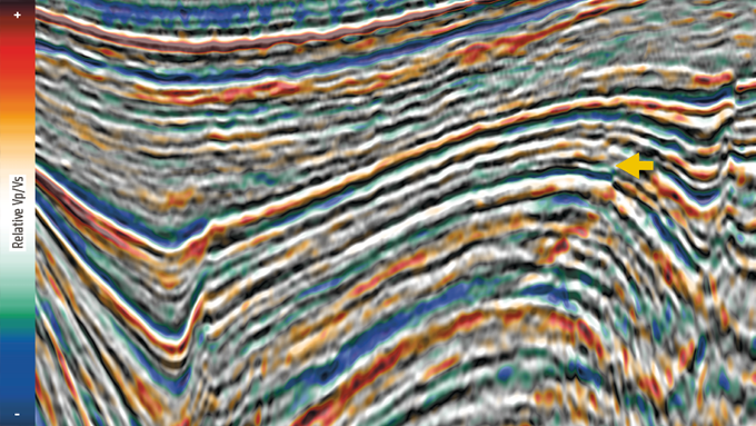
Low relative acoustic impedance (blue) and Vp/Vs (blue) in the apex of an undrilled structural closure reduces interpretation uncertainty and exploration risk
Explorers can now make better investment decisions across the range of open blocks available for direct negotiation across the offshore Congo, using reliable data for regional structural analysis to AVO screening at the prospect level. Following screening and review of the data, it will allow oil companies to high-grade areas for further exploration, and it is a perfect stepping-stone to new initiatives for nearfield exploration in nearshore areas.
KeyFacts Energy Industry Directory: PGS