Reconnaissance Energy Africa (ReconAfrica) provides an update on the acquisition of Enhanced Full Tensor Gravity ("eFTG") surveys and 2D seismic acquisition recently conducted in Namibia.
Initial results from the first phase show a high quality eFTG sub-surface image, with the rift bounding faults and other structural features delineated. In addition, the intra-rift highs and rift floors are well imaged. The image also puts into perspective the three stratigraphic wells drilled to-date (see insets in the figure 1 below). The overlaid seismic line shows a high degree of correlation between the eFTG data and the seismic interpretation. Further processing, modeling, inversion, and integration with the second phase eFTG data should considerably enhance the sub-surface imaging of the whole area, enabling de-risking and greater precision in selecting locations for the upcoming drilling program.
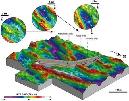
Fig.1: This is a 3D block diagram of GzHD (High Definition Gravity), residual filtered grid of the gravity data. The hot colours (white and red) show structural highs, cool colours (blue and purple) show structural lows. Note the insets showing the three stratigraphic wells drilled to date, and the strong correlation of the 2D seismic line to the eFTG data.
eFTG (Enhanced Full Tensor Gravity) – Phase 1 & 2
Following the successful completion of the first phase of the eFTG survey, the Company has once again contracted Metatek Group Limited, a worldwide airborne geophysical survey specialist based in the United Kingdom, to conduct a second phase eFTG survey of 2814 Km². The acquisition of this second survey is now complete with preliminary results expected by the end of the month. These surveys are in ReconAfrica's 25,000 square kilometers (6.3 million acres) PEL 73 exploration license in north-eastern Namibia. The total eFTG survey area is ~5,000 km². This additional survey extends contiguously to phase one in the Kavango Rift Basin to the south-east and the Damara Fold Belt to the south and south-west.
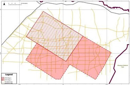
Fig 2: Hatched area shows the Phase 1 eFTG survey (2184 km², 540,000 acres) and the solid red area is the Phase 2 program (2814 km², 695,000 acres).
Shiraz Dhanani, ReconAfrica's Chief Geophysicist stated; "In the absence of 3D seismic, lateral continuity and mapping of structures is compromised because of the uncertainty in interpolation between more widely spaced 2D seismic lines. eFTG enables us to overcome this unpredictability. The images obtained so far, which are of very high quality, show the basin fault patterns, extent and continuity of intra-basin structural highs and feasible hydrocarbon traps, and possible hydrocarbon source kitchens (source rock) in the deepest parts of the basin."
2-D Seismic
The latest phase of the 2D seismic program has been completed. In total, ReconAfrica has acquired 2,755 line kilometers of 2D seismic. Generally, these programs have been designed to image the Kavango Rift and the adjoining Damara Fold Belt, all within the PEL 73 area. Nearly 2,000 kilometers of seismic data has been processed and interpreted, which will form an integral part of our upcoming annual resource report.
With the advantage of this new data, the Company is focused on interpreting and integrating all sub-surface data, including well data, 2D seismic, eFTG, geochemical data, and building an updated risk weighted prospect portfolio, enabling the development of a systematic drilling program.
KeyFacts Energy: ReconAfrica Namibia country profile