Data is now available from the SNS Vision project targeting exploration potential in the mature Southern North Sea gas province.
The final data supports exploration both for postsalt CO2 storage potential in the Triassic Bunter sand formation and near-field exploration targets.
SNS Vision covers open exploration acreage, as well as eight recently awarded CCS licenses. It provides reliable and consistent depth-migrated regional data for screening and evaluation of the carbon storage site, and includes additional deliverables that further support this.
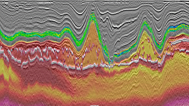
This line transects Bunter closures 38 and 21 and shows the estimated Triassic Bunter sand porosity and the seismic velocity below the top salt
Significance of 3D Vision Reprocessing
Twenty-six datasets included in the project have benefited from state-of-the-art depth imaging reprocessing, including a 2 millisecond broadband processing, modern deghosting, complex demultiple flow that is optimized for shallow water, and depth migration based on full waveform inversion (FWI).
This resulted in a seamless seismic data volume with improved resolution over approximately twelve thousand square kilometers that is suitable for both conventional exploration and CCS projects from shallow to deep.
Imaging of complex geology and salt tectonics has been effectively addressed through depth velocity model building (VMB), tomography, FWI updates, and Kirchhoff prestack depth migration (KPSDM). FWI has successfully resolved shallow features, and revealed shallow salt and cap rock details, as can be seen on the image below.
An accurate depth velocity model, with well control coming from thirty-one wells spread over the entire project area, was crucial for achieving high-quality seismic imaging of the Southern North Sea gas province. The uplift in subsurface imaging are apparent in the seismic line shown below, including the correct imaging and mapping of salt flanks and intra-salt heterogeneities, such as salt stringers.
Modeling & Interpretation
Following the SNS Vision seismic reprocessing effort, the PGS team performed an automatic regional horizon interpretation to rapidly interpret the volume and particularly the CO2 storage horizons, namely the Bunter Sand Formation interval.
Using an Eliis PaleoScan relative geological time (RGT) model, we rapidly generated detailed horizon stacks. We then derived inversion data, seismic facies volumes, spectral decomposition and visualized these at a chronostratigraphic level (an example is shown on the data library tile below). In less than one month, this method allowed us to interpret a significant area of around 12 000 sq. km without much a-priori seismic interpretation.
Quantitative interpretation (QI) characterization of this dataset has included petrophysics and rock physics analysis, well-to-seismic calibration, seismic stack(s) optimization or conditioning prior to seismic inversion for elastic property estimation, transform to reservoir properties (porosity), and integration of the above with the detailed high-resolution seismic interpretation. These results are also available.
Understanding the Rock Physics
To establish a proper reservoir understanding, we first developed a rock physics understanding by creating a rockAVO product. To this end, we screened twenty-five of the two thousand wells in the area. The wells used were selected based on log data availability, length, and quality. Porosity estimation was then performed for the BSF interval at regional scale, with use of the twenty-five rockAVO wells for the calibration and establishment of the transform between the elastic properties and the target property (porosity).
KeyFacts Energy Industry Directory: PGS l KeyFacts Energy: Seismic Acquisition News