This year GeoLogica will be running a number of field courses in Utah, in particular to the region around Moab and incorporating classic areas in Arches and Canyonlands National Parks, as well as Dead Horse State Park and well known localities such as Onion Creek, Bartlett Wash and Delicate Arch. Field course participants will have the opportunity to study a variety of geological disciplines, including stratigraphy, sedimentology and structural geology. But why is this area so attractive to geological field groups and what makes us return year after year to explore the geology of the region?
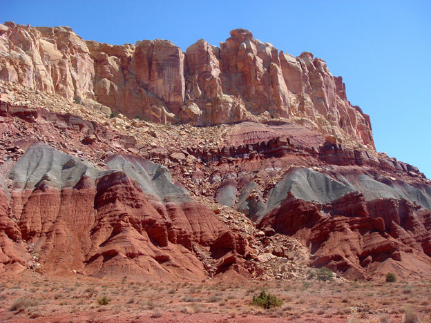
For those of us who are lucky enough to have visited southeast Utah, it’s difficult not to be inspired by the natural beauty of the area, even if you aren’t a geologist. The rocky and dry terrain displays a palette of colours, shapes, shadows and vistas that are hard to rival. The dry air, deep blue sky and often snow-capped summits of the La Sal mountains are guaranteed to impress. For the geologists among us, the Paradox Basin preserves some classic, text-book geological features that appeal to the academic as well as the applied geologist, whether exploring for mineral resources or hydrocarbons. Field excursions should always include the spectacular view from Dead Horse Point, where the Colorado River has cut down into the bedrock of the Colorado Plateau. Cliffs of over 1500 feet preserve a wonderous collage of sedimentary rocks, including shallow marine deposits of the Honaker Trail Formation, through mixed marine and terrestrial sequences of the Cutler Formation, up into aeolian and fluvial sequences of the Wingate and Kayenta Formations, to name but a few.
Salt tectonics and salt-sediment interactions are one of the top outcrop phenomena preserved in the landscape and they offer a window into analogous salt basins worldwide and the effects of salt diapirism. Of equal importance are the outstanding exposures of faults and structural geology features, like the classic Moab Fault and relay ramps of Canyonlands National Park. These offer an additional opportunity to focus on specialist topics, such as fault seal, fault rocks and smaller scale features such as deformation bands.
Utah really has something to offer every type of geologist, which is key to the geo-seduction and continued allure of the region. If you want to walk up a relay ramp, examine a salt wall, map a series of deformation bands or dissect the sedimentology of a Jurassic dune field, then southeast Utah has it all.
If you’d like to be seduced by the geology of Utah, join Geologica:
Structural Styles and Fault Characterization in Exploration and Production, Moab, Utah
Date: 6 - 12 Oct 2024
Duration: 6 days
Type: Field
Tutor: Russell Davies, PhD: Redlands Fault Geological Consulting LLC
This field course utilizes outstanding exposures of faults, fault rocks and stratigraphy in Colorado and Utah to examine seismic and subseismic scale fault geometries, fault zone architecture and controls on cross-fault flow. The aim of the course is to improve the understanding of uncertainties in the mapping of complex fault zones and the processes that create potential seals and compartmentalization in reservoirs in the subsurface for oil and gas, as well as CO2. Field exercises complement classroom lectures on the interpretation of faults, seal assessment and associated risks. Group exercises are included as prospect interpretation of compartmentalization from outcrop exposures.
You will learn to:
- Describe the regional geologic framework of the field area, the main stratigraphic units and the principal structural features.
- Characterize the mechanisms of faulting, fault propagation and the controls on the size, distribution and population of normal faults.
- Observe deformation and faults in outcrop to constrain likely structural and fault geometries in the subsurface.
- Characterize common trapping mechanisms and seal potential of fault rocks.
- Examine and assess fault rock properties and evidence of fluid flow at outcrop scale to better understand subsurface flow in reservoir and fault rocks.
- Establish trap and seal controls.
- Perform juxtaposition analysis and fault rock distribution mapping (SGR and CSF / SSF).
- Employ and interpret triangle diagrams.
- Understand key simulation techniques and modelling of faults.
This course is suitable for geologists, geophysicists and reservoir engineers engaged in the interpretation of faults and the assessment of fault seal in reservoirs for exploration, development and CO2 containment.
Exertion Level
The field component of this course requires a MODERATE exertion level. There will be some short hikes to outcrops (no more than 3.5 miles / 5.6km round trip), some over uneven and rocky ground with some short, steep inclines no greater than 700 feet (200 meters). The climate in southern Utah during the spring and fall is variable with temperatures from 50°F (10°C) to hot and dry up to 100°F (38°C). The elevation is between 4,000 and 5,000 feet (1200 to 1500 meters).
Women in Energy Field Experience: The role of Salt in Hydrocarbon Exploration, Energy Storage and Carbon-Reduction Mechanisms, Paradox Basin, Utah and Colorado
Date: 30 Sept-4 Oct 2024
Duration: 5 days
Type: Field
Tutors: Kate Giles: Professor Earth Sciences, University of Texas at El Paso and Cindy Yeilding: NE Director, Denbury Inc.
This course is aimed exclusively at women working in the energy industry, particularly in the geoscience, geotechnical and engineering fields. The primary technical goal is to provide a widely applicable introduction to the interrelationship between sedimentation and structural geology with a particular focus on salt tectonics and salt-sediment interaction. The geology is examined with reference to energy production, including hydrocarbon exploration and production, along with discussions around energy transition topics (CCUS, geothermal, hydrogen and energy storage). While the technical aspects are paramount, the course is also designed to provide networking and professional development opportunities. Evening discussions and activities will allow for exchange of ideas and experiences in a supportive and open atmosphere.
You will learn to:
- Describe the regional stratigraphy and principal structural features of the Paradox Basin, Utah.
- Characterize and interpret controls on Paradox Basin salt-related structures and key features of passive diapiric systems, including halokinetic sequences, caprock development, non-evaporite stringers / inclusions, welds, megaflaps, counter-regional faults, radial faults and burial wedges.
- Examine stratal geometries and halokinetic sequences and how these relate to intervals of salt inflation / evacuation and sediment flux.
- Assess the controls on basin fill architecture, fluid flow and deformation within the Paradox Basin and compare this to analogous salt basins worldwide.
- Understand the importance of salt basins to the energy industry for hydrocarbon production.
Level and Audience
Fundamental. This course requires a basic understanding of geoscience and will suit those working in the geoscience, geotechnical and engineering fields. The aim is to facilitate knowledge and experience exchange among the participants, so is open to women from a very wide range of experience levels.
Exertion Level
This course requires a MODERATE exertion level. There will be hikes to outcrops of up to 6.5km (4 miles) round trip. Some of these will encounter uneven and rocky ground with some short, steep inclines. The climate in southern Utah is typically warm to hot and dry with temperatures up to 37.5°C (100°F) and the elevation is between 1,250–1,500m (4,000–5,000 ft).
KeyFacts Energy Industry Directory: GeoLogica l KeyFacts Energy news: Training