John Donato (a founding member of Merlin) continues to enjoy an active retirement through his work with the UKOGL/Beneath Britain Group. In collaboration with Chris Pullan and Malcolm Butler, he has recently published a new gravity interpretation of the deep geology of England, which you can read in full on the UKOGL website here. The study employs a ten‑layer 3D gravity model in which each layer represents a major stratigraphic interval from the Lower Carboniferous to the Tertiary. Forward modelling of the gravity response for each layer, followed by summation of all ten contributions, produced a composite field that was subtracted from the observed gravity data to generate a residual gravity map (Figure 1).
This approach aims to remove the gravitational effects of the shallower, better‑constrained structures, thereby isolating anomalies associated with deeper and less well understood features. The resulting residual map displays anomalies across a wide range of wavelengths. Short‑wavelength anomalies (Figure 1A) are low in amplitude and, in several cases, are interpreted as possible Silurian–Devonian or Tremadocian sedimentary basins. In contrast, the long‑wavelength anomalies (Figure 1B) are substantially larger and appear to divide the region into several broad residual gravity domains. A particularly notable feature is a triangular area of low residual values across southern England, labelled Domain ‘S’ in Figure 1B. These domains are tentatively interpreted as expressions of large‑scale crustal architecture, potentially marking boundaries between crustal blocks amalgamated during earlier tectonic events.
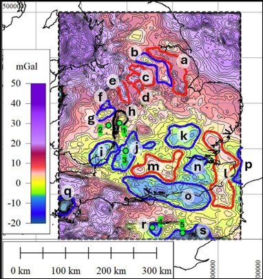
Figure 1A: Residual Gravity map with short wavelength features marked as discussed in the paper. Positive areas are shaded red with negative areas shaded blue and with a contour interval of 2mGal.
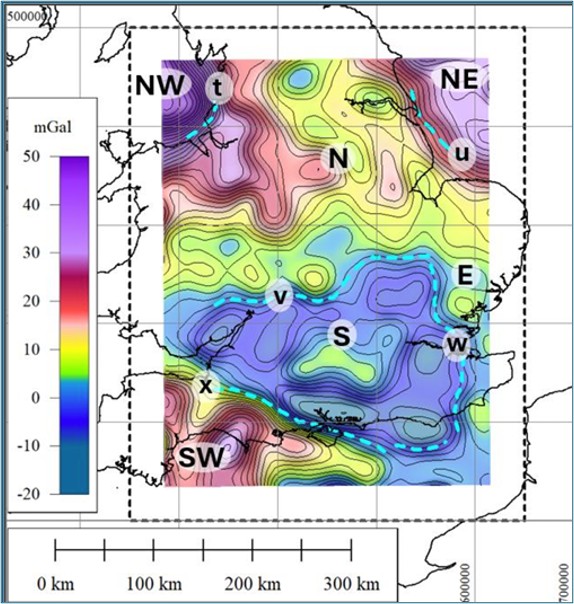
Figure 1B: Residual Gravity map with 50km low-pass filter applied and possibly showing features related to mid-deep crustal architecture. Positive areas are shaded red with negative areas shaded blue and with a contour interval of 2mGal.
The analysis raises several important questions. Why is the Midlands Microcraton not expressed in the gravity field? Does this imply it is not the significant basement block it has traditionally been considered? Why are the Variscan Front and associated Variscan structures not clearly identifiable? Is the deep, elongate, east–west trending residual low along the south coast (Anomaly ‘o’ of Figure 1A) the expression of a thick Upper and Lower Paleozoic basin? If so, should long‑standing tectonic models for southern England be reconsidered? These questions will no doubt stimulate further discussion within the Group in the months ahead.
We would like to acknowledge the important contribution to this work of our colleague and friend Andy McGrandle, who sadly passed away during the preparation of this paper. Andy provided helpful discussion and advice, including the initial recognition of the limited representation of the Midlands Microcraton within the gravity data. We also recognise his valued contributions to related work over the years, and we remember with gratitude his consistently friendly, knowledgeable and supportive character.
KeyFacts Energy Industry Directory: Merlin Energy Resources