Faroese Geological Survey (Jarðfeingi) is an institution under the Ministry of Environment, Industry and Trade.
The purpose of Jarðfeingi is to administer, research, consult and teach about oil, energy and geological nature values.
Jarðfeingi is responsible for all administrative tasks related to hydrocarbon exploration and production activities in the Faroe Islands.
Out of Round Bids
The Faroese government would like to draw the attention to the possibilities of Out of Round options in the Faroese area.
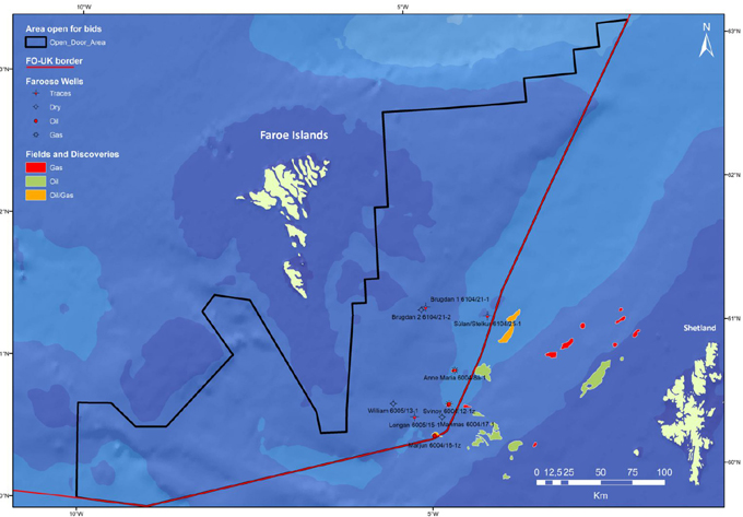
Maps showing the Open Door area (black outline) in Faroese sector.
Terms and Conditions
The terms for licenses applied for and awarded under the open door regime, are subject to the same terms and conditions which were passed in parliament for the previous round. This means that the current terms and conditions, for licenses awarded under the open door regime, are the same as for the last licensing round.
Procedure
- Individual companies or license groups can submit an application to Jarðfeingi at any time.
- Jarðfeingi will then advertise that an area has been applied for.
- Three months later the application will be evaluated.
- If there are compeeting bids, then the best bid will be awarded the license, provided that the proposed workprogram is sound.
- If there are no compeeting bids, then the license will be awarded to the sole bidder, provided that the proposed workprogramme is sound.
License Description
The terms and conditions in the Initial Term of an Exploration and Production Licence in the Faroese area are the same as the terms and conditions for the Innovative Licence in the UK area.
The Licence offers greater flexibility in the durations of the Initial and Second Terms. An applicant for an Innovate licence is able to propose the durations of the Initial and Second Terms, and among the permutations that may be proposed are those that represent those associated with each of the older licence types.
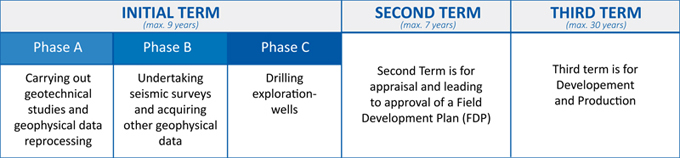
The Initial Term can now be subdivided into up to three phases, with the Work Programme being correspondingly divided:
- Phase A is a period for carrying out geotechnical studies and geophysical data reprocessing;
- Phase B is a period for undertaking seismic surveys and acquiring other geophysical data; and
- Phase C is for drilling.
- Phases A and B are optional and depend on the applicant’s plans. Every Work Programme must have at least a Phase C (just as a drilling commitment was the minimum Work Programme before the Innovate concept).
It remains the case that a Licence may only continue from the Initial Term into the Second Term if (among other things) the Initial Term Work Programme has been completed. Similarly, a Licence may only continue from one Phase into another if that part of the Term Work Programme associated with the earlier Phase has been completed and if the Licensee has committed to complete that part associated with the next. When continuing into Phase C, the licensee must also demonstrate the technical and financial capacity to carry out the Phase C part of the Work Programme.
Website l Linkedin 'People'